INIS CAORACH, MUTTON ISLAND
by Tom Kenny
In the year 1124, the town was put in a state of security and a strong castle was built at Dún Bun na Gaillimhe (the fortification at the mouth of the Galway River). Several times in the next century, the Kings of Munster invaded Connacht bringing death and destruction and usually destroying the town and the buildings on the island. In 1190, there is a reference to Lismacuan, ‘The fort on the Mouth of the Harbour’.
In 1641, an order was made that the islands of Mutton Island, approximately 3 acres, were to be made use of as a commonage by the inhabitants of Galway and the Liberties thereof. From a military point of view, the island was of great strategic importance. When the city was under siege in 1651 “The enemie…. Caused some Parliament vessels to anchor on Galway’s harbour, and to land some men on Sheepe Island to master the towns from them: with his ordnance very commodious, the number four score and ten choice mariners and other lustie men were then landed, to build half moones, redoubts and other inginier-works, to mount their artillerie against the towne …. The worke was begun, which if finished, doubtless the towne could not subsiste”.
But help was at hand. “Bryan Roe Oneyllie publickly offered himself …. And a partie of 300 men was picked out and marched with this new commander who thither arriuinge , commanded the whole partie upon pane of death to advance to give an assault upon the newe made works, which no sooner breathed than executed ….. This Irish partie had the killing of all the whole crue in the said island then extant, except one onley man, that narrowly escaped by swimming, got all their baggage, tooels and instruments, and demolished the works and turned home victorious without the losse of one man”. It was a great victory but sadly they eventually lost the war and the city surrendered on April 12th the following year.
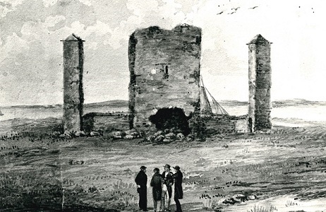
After the siege of 1691, the castle on the island was repaired and fortified. A fort was built beside it armed with 10 pieces of cannon and a company of soldiers. The castle was taken down in 1815 when the lighthouse was built. The light on top was first established on October 28th, 1817. In 1863, a Mr. Callwell, a member of the Ballast Board, described it thus ----- “This is a harbour light to guide ships past the island to the inner roadstead …. It is built in the centre of the island which is granite, surrounded with course, heavy shingle which is frequently moved about during strong gales. The light was originally sought for by a memorial from the merchants of Galway and also by various applicants ….. The tower is built of cut granite, solid walling and painted white, the railing of the gallery red. The light is cateplice of the …. Order is 33 feet above high water, and can be seen at a distance of 10 miles in clear water”.
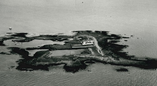
The lighthouse was in use until September 17th, 1958 when it was automated. Then a new problem gradually asserted itself as greatly increased background lighting along the coast began to swamp the island light, so it was decided to abolish it and the Margaretta East buoy and place a new lighted buoy called “Mutton Island” positioned south-east of the roadstead and north west of the shoals. The Harbour Commissioners light at the Leveret dates from the 1960s and also plays an important role in approaching the harbour. A leveret is a baby hare and this light is near Hare Island. On December 13th, 1977, Mutton Island’s light was extinguished. The buildings are still there but are now part of the sewage treatment plant complex.
Our first illustration today is titled “Ruins of the old castle on Mutton Island, site of the present lighthouse” and was drawn originally (but never used) for Hardiman’s History of Galway which was published in 1820. Our second image is a bird’s eye view of the island taken in the 1950s.