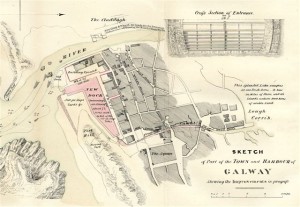
Galway Dock and Harbour Improvements, 1833 (07-06-2012)

“The town of Galway possesses many advantages of position for trade, which has hitherto been much cramped for want of adequate and secure accommodation for the shipping; great facilities present themselves for the construction of a wet dock. Several engineers of eminence agreed upon what ought to be the general nature of the work; and Mr. Kilally, adopting their principles, has recently drawn up the requisite plans and specifications, upon which a contract will be entered in to immediately; the preliminary steps having been taken of the purchase by inquisition of the premises and ground to be occupied”.
Thus began a report on public works in Ireland which was published in 1833 and which accompanied the map we illustrate here today. Another government report published 5 years later contained the following ---- “Galway is a tide harbour, the quays on both sides of the river being dry at low water. The rise and fall in ordinary spring tides is 14 feet. Galway Roads is the only place where a vessel can lie at low water. It lies to the south east of Mutton Island and has from 3 to 6 fathoms good holding ground.. At present this roadstead is exposed to the south-west gales, and requires a breakwater to be run out from the south end on Mutton Island to protect it. The breakwater would not extend more than two cables southward of Mutton Island to protect it, to embrace a good anchorage with 4 fathoms at low water spring tides.
Mutton Island being steep too, an excellent quay might be constructed at a moderate expense along its southern beach, connecting the minor part of the breakwater with the slate quay, now forming a larboard entrance into the river. Along the quay, ships would always lie afloat, and be well protected having their heads to the south-west, the best possible direction.
A ridge of rocks extends from Mutton Island to the main land, over which an excellent causeway might be constructed. The expense of the work would be amply repaid by the value of the land for building store-houses. A tram road along the causeway would facilitate the removal of cargoes; and for all commercial purposes, be equal to having the ships at the town.
A very good dock is now constructing at Galway, which at high water level will admit vessels drawing 14 feet. It is intended to communicate with a lake above the town, and thus open the resources of the country. This dock will be very useful for steam vessels until the breakwater is made, as they can lie afloat in it. Westerly gales alone could prevent a vessel beating out of Galway Bay; and sheltered as the bay is by the Arran Islands, if a ship could not beat out of it, she would make little progress outside”.
In the early part of the 18th century the extension of the quays down the river was continued and the Old Mud Dock, then called Eyre’s Dock, was constructed. In 1820, the shipping was either entirely in the river or in the Old Mud Dock, which still exists.
This map was published with the 1833 report and is fascinating for many reasons. It shows the area of the proposed new dock, the extent of the wharves and sites for building on either side of the dock. When I was young, I often heard the area referred to as “New Docks” and the map shows they were to be built where the old pool stretched just south of the former walls of the town. What we know today as the ‘Mud Dock’ is referred to as ‘The Old Dock’. Notice also the proposed new quays along the Claddagh and the small fishing boat harbour there. The Slate pier was the forerunner of Nimmo’s Pier. The cross section of the entrance shown is of the dock gates. The dock project was completed in 1842 at a cost of over £40,000.
The original plan for the canal is shown in red. As you can see, the lake came in as far as roughly where McSwiggan’s is today, and the canal started from there. It ran along part of the old town wall (which is marked in black), parallel to where Eglinton Street is today, crossed Williamsgate Street and through a large vacant site that corresponds to where the Eyre Square Centre is today. A number of bridges are shown on the map. By the time our map was published, this canal plan had already been abandoned as being too expensive.
The term ‘burying yard’ at Forthill looks strange until you think we call it a graveyard today. Two bridges are marked over the river and what we know as Quay Street is referred to as The Fishmarket. The quay area in front of the Spanish Arch was very different back then, obviously a good deal of land was reclaimed later when they built the river banks as we know them today.Trade improved on the construction of this commercial dock. It was a great achievement for its day, and gave facilities for berthing some of the largest vessels then afloat.
