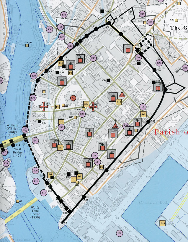
Galway c.1200 to c.1900 (21 01 16)
The above is the title of a newly published folding map by the Royal Irish Academy. It has been compiled by Jacinta Prunty and Paul Walsh using the extensive topographical information which they collected while working on a forthcoming book entitled ‘Galway’ in the Historic Towns Atlas series.
They also studied old maps of the city. This map extends from Newcastle Road to College Road and from Terryland to Nimmo’s Pier. The map and its extensive indices are unrivalled in their detail and afford a unique window into the earlier medieval topography and way of life in the city.
The heavy black line represents the old walls of Galway superimposed on a current ordinance map of the city centre. The various symbols we see are all described on the index to the map and also dated. So, for example E30 is listed as a ‘Meal and Flour Mill, 1656’.
Here is the key to some of the other symbols we see in our image; E37, Newtownsmyth Brewery, 1839 ; E23 Little Gate Mill, early 16th century ; E33, Mill 1735 ; E31, Mill, 1583 ; E47 Shambles, 1839 ; E29, Martin’s Mill, 1538 ; E11, Distillery, 1818 ; E15, Fishmarket, 1792 ; E14, Fish Market Salt Water, mid 17th century ; E1, Agricultural bank, 1839 ; E8, Cattle Market, mid 17th century ; E46, Shambles, 1802 ; E13, Fish Market Fresh water, mid 17th century. G1, College Cross, 1508 ; G13, Market Cross, 1583 ; G16, St Brendan’s Well, 1684 ; G4, Dovecote, mid 17th century.
C1 Agnes’ Tower, mid 17th century ; C2, Alexander’s Tower, mid 17th century ; C3, Athey’s Tower, mid 17th century ; C5, Gavia’s Tower, mid 17th century ; C10, Little Gate River Tower, 1583 ; C37, Blake’s Castle, 1592 ; C18, Old Quay Gate 1608 ; C15, Middle West Gate, 1608 ; C22, Quay Gate, pre 16th century ; C11, Martin’s Tower, 1519 ; C21, Poke’s Tower, 1583 ; C16, New Tower, Shoemaker’s Tower 1424 ; C39, Castle Barracks ; C25, East or Upper Citadel, 1652 ; C6, Great Gate, 1277-80 ; C35, William’s Gate, 1689 ; C26, Lion Tower Bastion, 1646. D19, Patrician Brother’s School, 1827 ; D26, Tholsel, 1645 ; D25, Tholsel 1486, Town Gaol 1496 ; D13, Dominican Girl’s School, 1767 ; D9, County Gaol, 1686 ; D11, Custom House, 1686 ; D7, County Courthouse, 1686 ; D2, Charitable School, 1787 ; S15, Galway Mechanics Institute, 1838.
A11, Augustinian Nunnery, 1839 ; A37, St. Patrick’s Monastery ; A8, Augustinian Friar’s Residence, mid 17th century ; A19, Franciscan Friar’s Residence, mid 17th century ; A13, Carmelite Friary, 1648 ; A17, Dominican Nunnery, 1686 ; A17, Jesuit Residence, mid 17th century ; A25, Poor Clare Nunnery, 1642 ; A29, Rich Clare Nunnery, early 17th century ; A12, Capuchin Friar’s Residence, mid 17th century.
This map contains of which we show a small section, an extraordinary amount of information and will bear a lot of study. It is available in good bookshops for 10euro and is highly recommended.
There should be a framed copy in all school in the city.